One city.
Every way
to move a box.
Four transportation modes. Five Class I railroads. One freight capital quietly running the American supply chain from the middle of the map.
This is Memphis.
Blues, barbecue, the Pyramid, the river. The logistics backbone you've been scrolling through sits underneath a 650,000-person city with a culture as distinct as any in America.


At a bend of the Mississippi, where four interstates cross and five railroads meet, a single city quietly moves more American freight than most nations move at all.
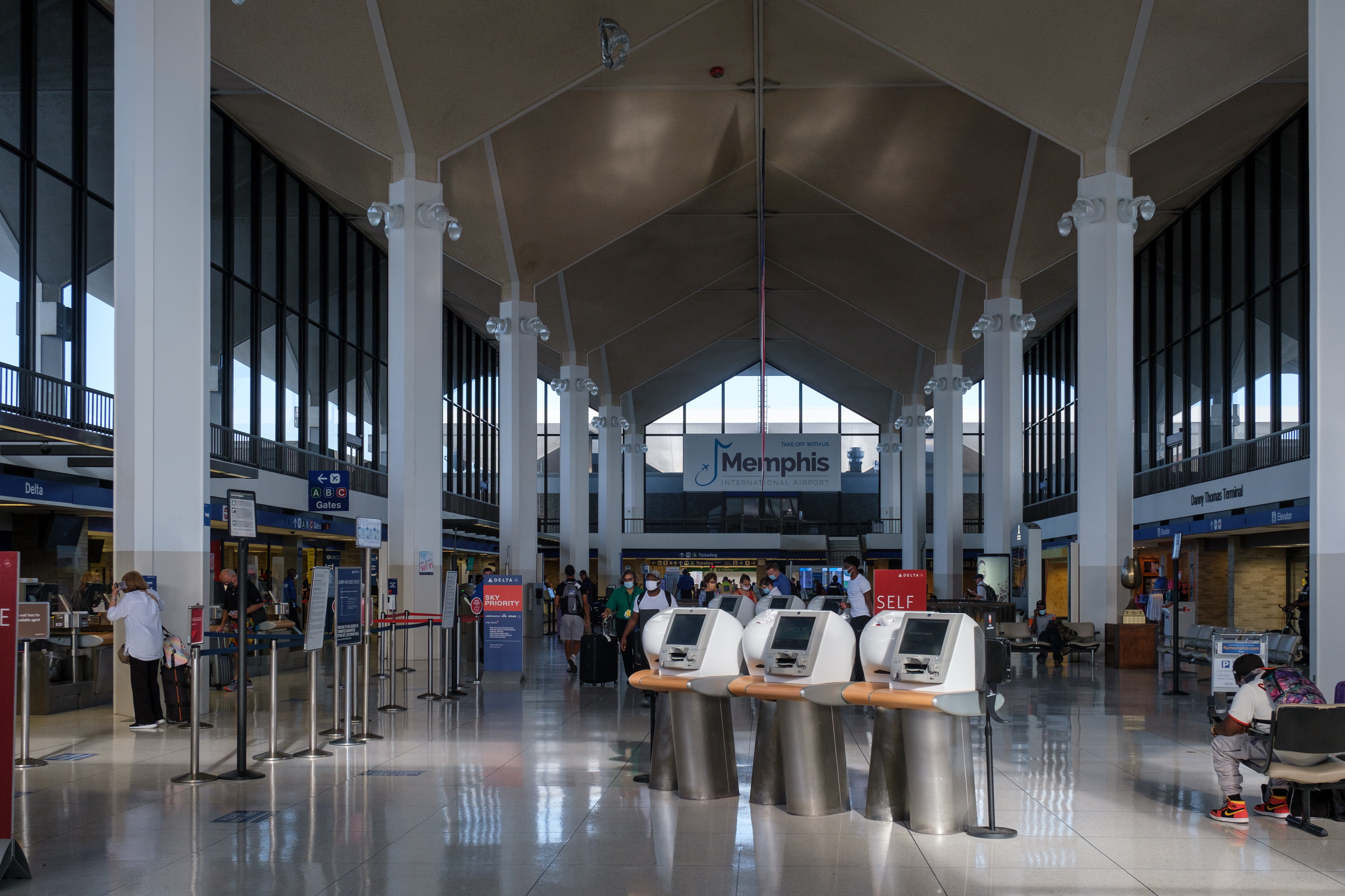
The FedEx World Hub — a city inside an airport.
Memphis International (MEM) sits on 3,900 acres south of downtown with four runways. Inside its northwest quadrant, on a 3.5-million-square-foot campus at 2874 Business Park Dr, FedEx runs the largest express-cargo sort in the world.
- Runways
- Airport boundary
- Interstates
- FedEx aircraft (live)
- Other aircraft (live)
- Air hub · Memphis-Shelby County Airport AuthorityMemphis International Airport (MEM)
- Air hub · FedExFedEx Express World Hub
- Air hub · UPSUPS Memphis Air Hub
Every weeknight around 10 p.m., aircraft begin stacking inbound from every US time zone and from Europe, Asia, and Latin America. By 2 a.m., roughly 150 FedEx jets will have landed, unloaded into the Matrix sort system, and begun pushing back with redistributed freight. The Matrix has more than 300 miles of conveyors and moves ~500,000 packages per night.
FedEx is not the only tenant. UPS runs a secondary overnight air hub on the east side of the field, and Amazon Air operates a dedicated cargo ramp supporting its MEM-codeshare fleet. The map above shows the real runway alignment, the airport boundary, and the named cargo facilities — click any pin for details.
The live aircraft count (top right) is pulled from the OpenSky Network's public ADS-B feed, filtered to the 100-nautical-mile ring around MEM. Callsigns beginning with FDX are highlighted — most will land here within the hour.
One of four cities where all five meet.
Only four U.S. cities are served by all five of the largest Class I freight railroads — BNSF, CN, CSX, Norfolk Southern, and Union Pacific. They are Chicago, St. Louis, New Orleans, and Memphis. The map above shows each carrier's named intermodal or classification yard in the Memphis metro.
- BNSF Railway
- Canadian National (CN)
- CSX Transportation
- Norfolk Southern
- Union Pacific
- Shortline / unknown
- Rail yards
- Rail yard · BNSFBNSF Memphis Intermodal Facility3660 Forest Hill Irene Rd, Memphis TN185 acres · opened 2011 · capacity ~1M containers/yr · eastern terminus of BNSF transcon
- Rail yard · Canadian NationalCN Intermodal Terminal (Harrison Yard)1355 Kansas St, Memphis TNGateway for Canada–Gulf freight · connects to CN's former IC main line
- Rail yard · Norfolk SouthernNS Forrest YardChelsea Ave, Memphis TNNS intermodal + automotive · serves Crescent Corridor
- Rail yard · CSXCSX Leewood Yard (Memphis Intermodal)1330 Leewood Dr, Memphis TNCSX's gateway for Southeast–Mid-South intermodal
- Rail yard · Union PacificUP Memphis Intermodal (Marion, AR)Marion, ArkansasUP's Memphis-area gateway, just across the Mississippi via the Harahan Bridge
BNSF's flagship facility — the Memphis Intermodal Facility at 3660 Forest Hill-Irene Rd — opened in 2011 on a 185-acre site and was designed for one million container lifts per year. It sits on the Transcon main line that runs to Los Angeles. CN's Harrison Yard on Kansas Street is a legacy Illinois Central facility and forms the southern gateway of CN's Chicago–New Orleans spine. NS Forrest Yard on Chelsea Avenue feeds the Crescent Corridor to Atlanta and New York.
CSX's Memphis Intermodal (Leewood Yard) handles the Southeast interchange, and UP's Memphis-area operations are concentrated across the river in Marion, Arkansas — reached via the Harahan Bridge, a dual rail + pedestrian span that parallels the adjacent 1892 Frisco Bridge.
The magenta polygons on the map are the actual rail-yard parcels from OpenStreetMap. Dashed magenta lines are mainline rail. Click a pin for address and operator details.
The Port of Memphis and President's Island.
The International Port of Memphis is the 5th-largest inland port in the United States. Its 66 terminals are concentrated on President's Island — a man-made industrial peninsula at the south edge of downtown, visible as the cluster of cyan + grey polygons on the map above.
- Mississippi River
- Port / harbor facilities
- Industrial zones
- Interstates
- River bridges
- Port · Memphis & Shelby County Port CommissionInternational Port of Memphis5th-largest inland port in the US · ~10M+ tons/yr · President's Island industrial complex · 66 terminals
- BridgeHernando de Soto Bridge (I-40)I-40 Mississippi River crossing · the only I-40 bridge at Memphis
- BridgeMemphis–Arkansas Bridge (I-55)I-55 Mississippi River crossing
- BridgeHarahan BridgeDual rail + pedestrian bridge · UP main line
- BridgeFrisco BridgeBNSF rail bridge · opened 1892
A standard 15-barge tow — one that can be handled on the lower Mississippi — moves the cargo equivalent of 216 rail cars or 1,050 trucks. The port handles more than 10 million tons annually, including grain, steel, petroleum, cement, and petcoke. Four river bridges cross at Memphis: the Hernando de Soto Bridge carries I-40, the Memphis–Arkansas Bridge carries I-55, and the Harahan and Frisco bridges carry rail.
The gauge-height widget (top right) reads live from USGS station 07032000, the official river-stage gauge at Memphis. The river here typically ranges from 0 ft at drought low to 48+ ft in major flood, with a navigation pool around 10–15 ft being routine.
Zoom and pan the map to see the actual port layout, the bridge alignments, and how the industrial zones radiate out from the harbor.
Four interstates, one day's drive to most of America.
I-40 (east–west), I-55 (Chicago–New Orleans), I-22 (to Birmingham), and I-69 (the NAFTA corridor) all cross in Memphis. The I-240 beltway forms an inner loop around the metro. From here, a Class-8 truck can reach ~75% of the U.S. population in under 48 hours.
- Interstates
- Mississippi River
- Distribution center / HQ
- Airport / cargo hub
- Rail yard
- Port
- River bridge
- I-40 · East–WestOKC ↔ Nashville · 2,555 mi coast-to-coast
- I-55 · North–SouthChicago ↔ New Orleans · 964 mi
- I-22 · SoutheastMemphis ↔ Birmingham · 213 mi
- I-69 · NAFTA corridorCanada ↔ Mexico (under construction)
- I-240 · Metro loopMemphis bypass · 25 mi
- Distribution / HQ · NikeNike North America Logistics Campus5155 E Holmes Rd, Memphis TN~3M sq ft · Nike's largest distribution campus globally
- Distribution / HQ · AmazonAmazon MEM1 Fulfillment Center3292 E Holmes Rd, Memphis TNNon-sortable fulfillment · opened 2013
- Distribution / HQ · AmazonAmazon MEM24505 Lamar Ave, Memphis TN
- Distribution / HQ · AmazonAmazon MEM6 Air HubAmazon Air hub at MEM · cargo aircraft operations
- Distribution / HQ · Williams-SonomaWilliams-Sonoma DC4700 Hickory Hill Rd, Memphis TNEast Coast furniture + home-goods fulfillment
- Distribution / HQ · AutoZoneAutoZone Headquarters + Distribution123 S Front St, Memphis TNFortune 500 HQ · distribution nerve center for 7,000+ US stores
- Distribution / HQ · ServiceMasterServiceMaster Global HQ150 Peabody Pl, Memphis TN
- Distribution / HQ · International PaperInternational Paper HQFortune 500 HQ · global supply chain for paper + packaging
- Distribution / HQ · FedExFedEx Corporation HQ942 S Shady Grove Rd, Memphis TNFortune 500 HQ · the company Memphis logistics was built around
- Distribution / HQ · TargetTarget Import Warehouse1.6M sq ft import distribution center
The map above highlights the actual interstate alignment through the metro. Every amber line is a real motorway segment from OpenStreetMap, not a stylized arc. You can see the I-40 / I-55 split downtown, the Hernando de Soto Bridge crossing, and how I-240 rings the city with on-ramps to every major distribution corridor.
Magenta pins are real distribution centers and Fortune 500 logistics HQs: Nike's 3M-sq-ft campus on E Holmes Rd, AutoZone's downtown HQ on Front St, FedEx Corporation's global HQ on Shady Grove Rd, the Amazon MEM1/MEM2 fulfillment centers, and more. Click any marker for the address and the operator's footprint.
That cluster of pins is the reason Memphis has roughly 310 million square feet of industrial space in its metro — a footprint larger than the entire borough of Manhattan, laid out for pallets.
Who actually ships from here.
Memphis isn't just a transit point — it's a headquarters town and a fulfillment town. Fortune 500 logistics operators run global supply chains out of city limits. Below: a sampling of the major facilities anchoring the metro.
Locations and details compiled from public real estate filings, operator press releases, and OpenStreetMap. Coordinates are approximate to the facility parcel centroid.
Nowhere else
do all four converge.
Other cities do pieces of this story well. Memphis does every piece of it, at the same latitude, within a single metropolitan footprint.
| Metro | Top-5 global cargo airport | All 5 Class I railroads | Mississippi River port | Interstate crossroads |
|---|---|---|---|---|
| Memphis | ||||
| St. Louis | ||||
| New Orleans | ||||
| Chicago | ||||
| Louisville | ||||
| Los Angeles |